Ancient Near East Empires Map and Timeline
Egypt, the Hittite kingdom, Mitanni, Assyria and Babylonia belonged to the same broad ancient Near Eastern world, but their greatest periods of power did not occur together. Begin with the regional map, then compare the dated settings below. A physical landscape can remain recognizable while its rulers, capitals and political boundaries change.
This guide answers three different questions: where these powers were based, which periods can reasonably be compared, and what their names establish when they appear in a biblical passage. It does not combine their largest territories into a single supposedly contemporary empire map.
Find the regions on the map
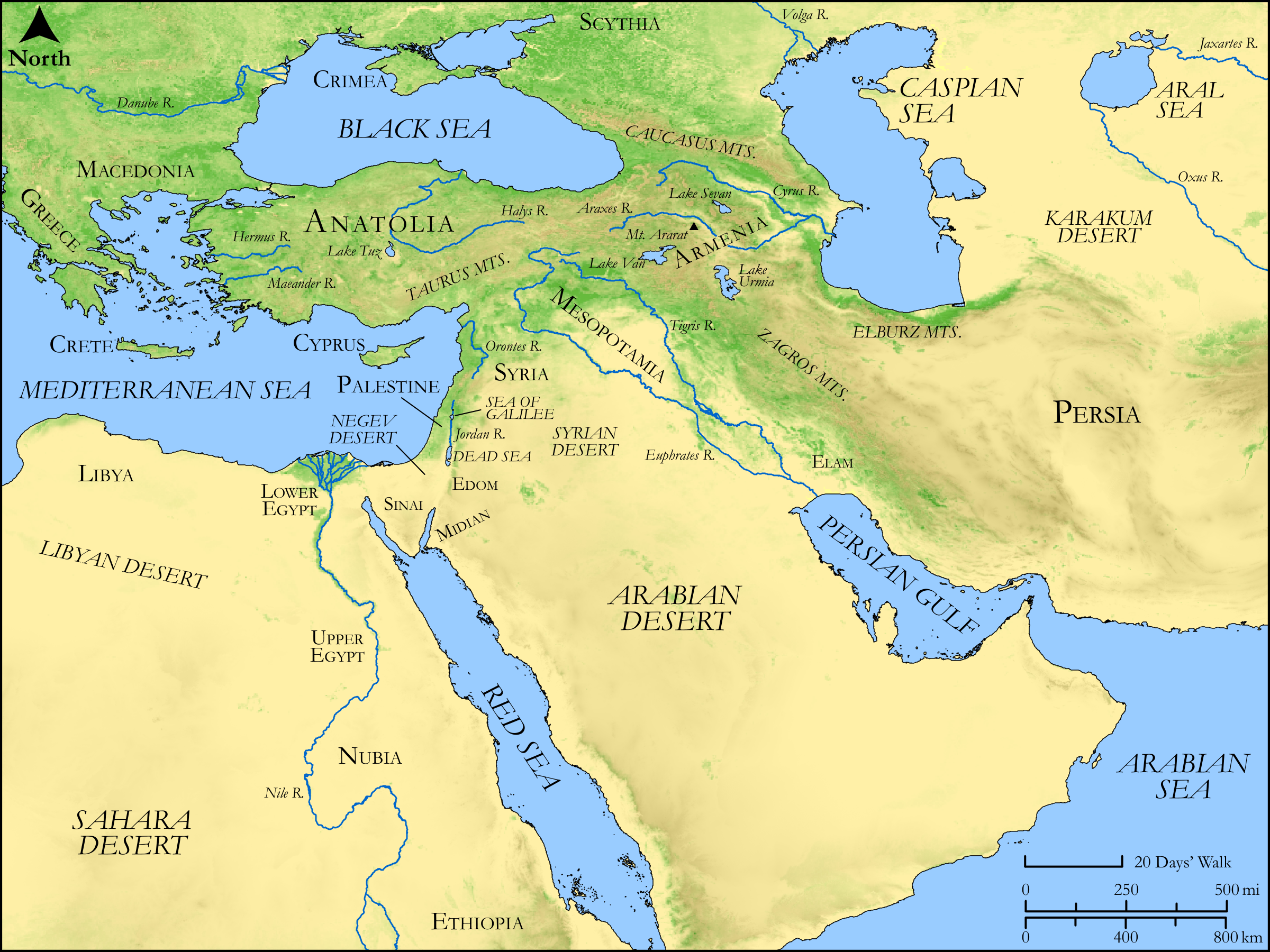

Start in Egypt, where the Nile provides a different geographical axis from the two great rivers of Mesopotamia. Follow the eastern Mediterranean coast north into the area labeled Palestine and Syria. Farther north, Anatolia lies beyond the Taurus Mountains. To the east, the Euphrates and Tigris run across Mesopotamia toward the Persian Gulf.
The map's label “Syria” is geographical here. It does not make every kingdom in that region the same political state, and it should not be confused with Assyria. Likewise, Babylon was a city and Babylonia a larger region; an empire ruled from Babylon could extend far beyond that region. The map's physical colors indicate terrain, not which king collected tribute.
Compare the powers by period
| Power or setting | Where to look | Historical time frame used here | A distinction to keep |
|---|---|---|---|
| Egypt's New Kingdom | Nile valley; then the eastern Mediterranean corridor | About 1550–1070 BC in the Metropolitan Museum's periodization | This is one phase of a much longer Egyptian history, not the beginning of Egypt or a date for Moses. |
| Hittite kingdom | Anatolia and northern Syria | About 1650–1200 BC for its major period of dominance in the Met's account | A state based at Hattusha should not be equated automatically with every later biblical reference to Hittites. |
| Mitanni | Northern Mesopotamia, between Anatolia and the Assyrian heartland | A major power in the fourteenth-century BC Amarna correspondence | The diplomatic setting is contemporary with New Kingdom Egypt; it is much earlier than Nebuchadnezzar II. |
| Neo-Assyrian expansion | Northern Mesopotamia, then west toward Syria and the two Israelite kingdoms | Ninth–seventh centuries BC | Middle Assyrian history precedes this phase. Assyria and Babylonia were distinct centers even when one ruled the other. |
| Old Babylonian setting | Southern Mesopotamia | Hammurabi in the eighteenth century BC | This is not the kingdom of Nebuchadnezzar II, who ruled more than a millennium later. |
| Neo-Babylonian kingdom | Babylonia and the western lands taken from Assyrian control | Nabopolassar's accession in 626 BC to the Persian conquest in 539 BC, in the chronology discussed with ABC 3 | The fall of Nineveh in 612 BC belongs within this rise; it is not Hammurabi's accession. |
The dates organize comparisons. They do not mean that a power held the same territory throughout its entire period. A raid, a tributary relationship and direct administration are different kinds of political involvement. See the separate Assyrian study for a map with several expansion layers, and the Babylonian study for the sequence involving Judah.
What the Amarna letters add
The Met's account of the Amarna letters distinguishes letters from dependent Levantine rulers from those exchanged between Egypt and other great kings, including rulers of Babylonia, Assyria, Mitanni and Hatti. That distinction gives a better picture of the fourteenth century BC than a list claiming that one empire simply replaced another everywhere.
For example, a local ruler's deferential request and a great king's discussion of gifts are evidence of different relationships. Neither letter by itself draws an entire frontier. The correspondence helps show contemporaries interacting; the later Assyrian and Babylonian conquest narratives belong to different historical settings.
Can the map identify Moses' pharaoh?
Exodus 1 describes a new king who oppresses the Israelites and names the store cities Pithom and Raamses. Exodus 2:1–10 tells how Pharaoh's daughter rescues Moses. Neither passage names that king or daughter. Naming Ahmose, Hatshepsut or Thutmose III requires a further chronological argument; their names cannot be read from the map.
First Kings 6:1 gives a relative interval of 480 years between the Exodus and Solomon's fourth year. Converting that statement into an absolute calendar date requires a date for Solomon's reign and an interpretation of the interval. This guide therefore does not present 1445 BC, a particular pharaoh, or a precise lifespan for Moses as an independently established result of Egyptian geography.
Which Hittites does a passage mean?
The Met's Hittite history describes a major Anatolian state and the survival of Hittite traditions in northern Syrian dynasties after the empire's collapse. That difference matters when reading later biblical references. First Kings 10:28–29 mentions trade involving kings of the Hittites and Syria; 2 Kings 7:6 reports the Syrian army's fear that Israel had hired Hittite and Egyptian kings.
In the second passage, the supposed arrival of those armies is the frightened soldiers' explanation of a sound. It is not a report that a Hittite imperial army actually entered Israel. A useful reading question is therefore both geographical and literary: which location and period are relevant, and whose claim is the narrator reporting?
Was one of these the first empire?
The five names on this page are not an exhaustive beginning of Near Eastern political history. The Met, for example, identifies objects from an Akkadian period around 2350–2150 BC, earlier than the principal settings compared here. “First empire” also requires a definition of empire and a wider historical investigation. This map cannot establish a “first world power” ranking by the order in which its regional names are read.
Questions for a map study
- Find the Nile, Euphrates and Tigris. Which power's heartland belongs with each river system, and which labels are regions rather than capitals?
- Choose two powers that appear together in the Amarna correspondence. Compare them before moving to the much later Neo-Assyrian period.
- Read 2 Kings 7:6. Separate the soldiers' explanation from what the verse says happened. What would a map add, and what could it never prove?
- For any claimed “peak empire” map, ask for its date, legend and treatment of tributary states before estimating its area.
Sources and map credit
- King James Version: Exodus 1; Exodus 2:1–10; 1 Kings 6:1; 1 Kings 10:28–29; 2 Kings 7:6.
- Metropolitan Museum of Art: Egypt in the New Kingdom; The Hittites; The Amarna Letters; Assyria, 1365–609 BC; Babylon; Akkadian figurine, object 59.41.19. Dates and historical summaries are attributed to these museum accounts; the object record establishes a dated material context, not a first-empire ranking.
- ABC 3, Fall of Nineveh Chronicle, Livius edition: its introduction discusses Nabopolassar's 626 BC accession, and its translation distinguishes the coalition's capture of Nineveh from later events.
- Biblica Open Bible Maps OT001, repository revision baa718b1ed1ae2d735d9deebf76159b588da8a47: resource license statement and publisher's additional information. The original map is reproduced without modifications or a site ownership mark.