Middle East Map
The Middle East is a regional term whose coverage depends on the source. A sheet titled “Middle East” can include neighboring land without classifying every visible country as Middle Eastern. This guide uses a dated political map to explain the region's geography, its relationship to UN statistical groups, and the limits of using a modern map for biblical history.
The displayed map is the CIA's August 2013 edition. It is useful for broad orientation, but its political labels and explanatory notes are historical source material. They should not be read as a description of present control, diplomatic recognition or embassy locations.
Open the Middle East Reference Map
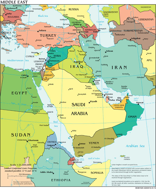
Locate the Mediterranean Sea on the left, the Arabian Peninsula in the center and south, and Iran to the northeast of the Persian Gulf. Then follow the Red Sea between northeastern Africa and Arabia. This gives a physical framework that remains useful when comparing different regional definitions.
Which Places Are Included?
The image covers Egypt, the eastern Mediterranean, Türkiye, the Arabian Peninsula, Iraq and Iran, together with parts of adjacent regions. It also shows places such as Ethiopia, Somalia, Kazakhstan and Uzbekistan. Their appearance at the edge tells you about the map's extent, not that they all belong to a single official Middle East list.
For a reproducible comparison, the UN M49 scheme uses Western Asia, rather than a geographical group named Middle East. Western Asia and the coverage of this sheet overlap but are not identical. The following distinctions explain why country totals differ between sources.
| Places to locate | UN M49 grouping | What the distinction means |
|---|---|---|
| Iraq, Israel, Jordan, Lebanon, State of Palestine, Syrian Arab Republic | Western Asia. | The eastern Mediterranean and its inland neighbors are part of this statistical group; the 2013 map uses its own older labels and notes. |
| Bahrain, Kuwait, Oman, Qatar, Saudi Arabia, United Arab Emirates, Yemen | Western Asia. | Use the gulf and peninsula outlines to find the smaller labels; land area and label size are different. |
| Armenia, Azerbaijan, Cyprus, Georgia, Türkiye | Western Asia. | The northern and island entries show why Western Asia is wider than some readers expect. |
| Iran | Southern Asia. | Its prominent inclusion on the Middle East sheet does not change its M49 assignment. |
| Egypt and Sudan | Northern Africa. | A map centered on the Middle East crosses a continental statistical boundary. |
| Djibouti, Eritrea, Ethiopia, Somalia | Eastern Africa. | These neighboring countries provide Red Sea and Gulf of Aden context; visibility alone does not establish regional membership. |
| Kazakhstan, Turkmenistan, Uzbekistan | Central Asia. | The upper-right edge includes part of a neighboring Asian subregion. |
M49 says these groupings serve statistical convenience and do not imply political affiliation. Its country-or-area designations also do not express a judgment on legal status or frontier delimitation. Use its named grouping when comparing statistics, and state any broader or narrower Middle East definition separately.
Find the Region Through Its Waterways
The Mediterranean, Red Sea, Persian Gulf and Arabian Sea offer a practical route through the map. Find Egypt and the Sinai area between the Mediterranean and Red Sea; then trace the Arabian Peninsula down to Yemen and Oman. Follow the Persian Gulf north toward Kuwait and Iraq, and locate Iran on its opposite side.
The map also labels the Euphrates and Tigris across the northern and eastern part of the region. Their paths help orient a reader moving between a modern sheet and an ancient Mesopotamian map. A river's presence is not a guarantee that every ancient settlement, channel or border matches its modern depiction. The Euphrates geography and passage guide supplies a more appropriate ancient context.
A useful exercise is to identify a place by two surrounding features: Jordan beside the eastern Mediterranean inland corridor, for example, or Yemen beside the Red Sea and Gulf of Aden. This avoids making country colors carry information they do not contain. The colors on this political map distinguish units; they do not represent religion, ethnicity, population or petroleum reserves.
How Big Is the Middle East?
There is no meaningful single area total until the included territory is specified. Summing all countries visible in the rectangle would include surrounding African, European and Central Asian land and would not measure a consistently defined Middle East.
The printed scale is 1:21,000,000: at its intended printed size, one centimeter represents 210 kilometers. Screen resizing changes that relationship, so use the kilometer or mile distance bar when viewing the image online. The sheet specifies a Lambert conformal conic projection with standard parallels at 12°N and 38°N. It is not an equal-area display; apparent shapes and printed scale should not be used to calculate a regional surface area.
The small map can answer broad location questions. It cannot supply current population, humanitarian need, energy production or economic rankings. Those measurements require separately dated data with a stated territorial scope. Keeping them separate also prevents an old map from silently dating an apparently current statistic.
Use the Map Alongside Biblical History
Begin with the period of the passage, then identify the ancient place-name, and only then compare its approximate modern position. The names and borders of ancient Israel, Judah, Assyria, Babylon and Persia should be examined in period-specific guides such as the ancient Near East empires comparison. A modern national outline does not reconstruct an ancient empire's extent.
The 2013 source's footnotes about Israel, the West Bank and Gaza belong to that edition. They remain visible so the map is not stripped of its qualifications, but this page does not present those notes as a current legal or political summary. Nor does a country's modern location establish a biblical genealogy or a prophetic identity. Each such claim needs evidence beyond the map.
For the broader continental setting and the five UN Asian subregions, continue with the Asia map-reading guide. Read the two maps as overlapping views with different frames, rather than as competing declarations of where one region must end.
Sources and Map Credit
- UN Statistics Division, M49 geographical regions and country-or-area entries, checked November 10, 2026; Western, Southern and Central Asia, and Northern and Eastern Africa, together with the source's classification disclaimers.
- CIA, Middle East, August 2013. Pinned Commons source description and public-domain record; CIA source and copyright policies. The map is attributed government material, not an original work of LetsLearnTheBible.com, and does not imply agency endorsement.
