Euphrates River Map
The Euphrates is a named river in biblical geography, a boundary in several land descriptions, and part of two distinct visions in Revelation. Start by locating it beside the Tigris on the map, then distinguish what each passage says from what the map can show.
The original questions: How will the Euphrates River help to fight Jesus' Second Coming? Why are four demons bound within it?
Revelation 16:12 says the river's water is dried up to prepare a way for the kings from the east. The following verses describe spirits gathering kings for battle. Revelation 9:14, however, calls its four bound beings angels; it does not identify them as four named demons. These are separate scenes, not one geographical report of spirits living at a mapped river location.
Locate the Euphrates on the map
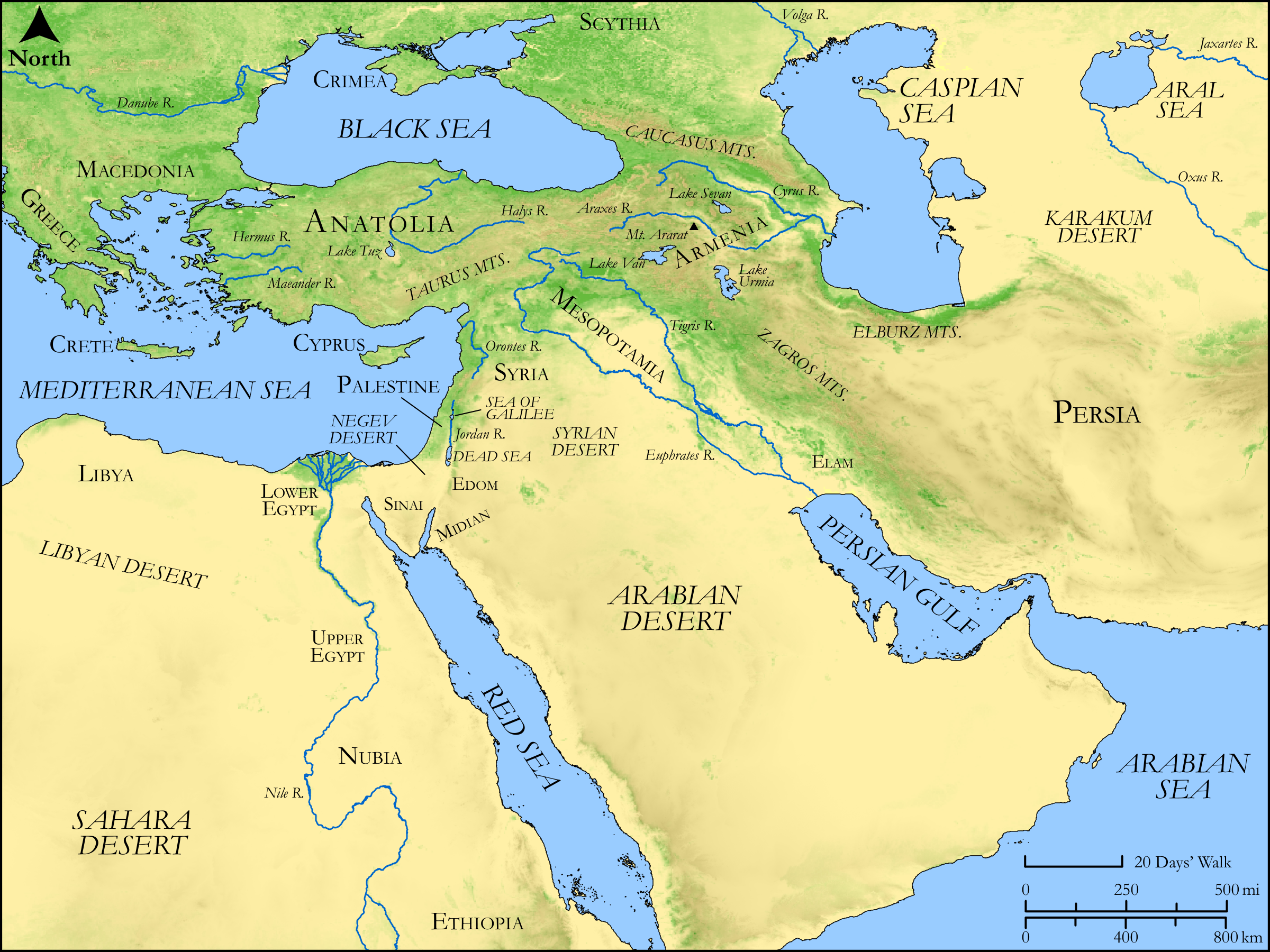

How to read its course and surrounding regions
- Find the upper part of the map. The Anatolia and Armenia labels orient the upland setting. The river lines extend from that broad northern area toward Mesopotamia. This regional drawing does not resolve the precise source of every tributary.
- Trace the Euphrates, rather than the nearest blue line. Through much of Mesopotamia it lies west of the Tigris. Follow each label along its own channel; the two rivers are distinct even though they share the same regional setting.
- Look toward the Persian Gulf. This gives the overall northwest-to-southeast orientation of the river corridor. The drawn coastline is background geography, not a reconstruction of the Gulf's shoreline in Abraham's lifetime.
- Return to the western side. Syria, the Mediterranean and the land of Israel show how far the Euphrates setting extends beyond the local landscape of Jerusalem. A reference to the river can concern a regional boundary, a military setting or an image of imperial power, depending on the passage.
- Use the legend and scale for orientation. Relief shading depicts landforms; region names label broad areas. The distance scale does not establish an army's route or travel time, and the map's walking scale is not evidence for a biblical journey's duration.
For a close reading, open the full image or use the map's horizontal scroll area. The map intentionally retains the publisher's labels and credit. The following table supplies the textual context that a physical map alone cannot provide.
What the river does in different passages
| Passage | Role in the passage | How the map helps | Limit to observe |
|---|---|---|---|
| Genesis 2:8–17 | The fourth named river in the description associated with Eden. | Shows the Euphrates and the neighboring Tigris as recognizable geographical names. | The river name alone does not locate Eden at a modern coordinate or identify every other river in the account. |
| Genesis 15:7–21 | A boundary in the land promise to Abram, extending from the river of Egypt to the great river, the Euphrates. | Shows the Euphrates in relation to the wider land corridor. | The passage says “river of Egypt.” Silently replacing that expression with “Nile” would decide an identification the wording itself does not explain. |
| Deuteronomy 1:6–8; 11:22–25; Joshua 1:1–9 | A limit in descriptions of the land before Israel. | Helps the reader see the scale of the regional language. | A promised boundary is not a map of territory occupied continuously in every later period. |
| Isaiah 8:5–10 | The river's powerful waters form an image associated with the king of Assyria and his advance. | Locates the broader Mesopotamian setting behind the comparison. | The flooding language should be read as the passage's image of overwhelming power, not a measured account of a particular river flood. |
| Jeremiah 46:1–12 | The setting of an oracle concerning Egypt and Pharaoh Necho's army by the Euphrates at Carchemish. | Places the named river within a historical military setting. | This scene has its own people and context; it is not the same event as the visions in Revelation. |
| Revelation 9:13–21; 16:12–16 | A location in the sixth-trumpet vision and a river dried in the sixth-vial vision. | Identifies the geographical name used in the visions. | The physical map cannot identify supernatural beings, future national alliances or an exact timetable. |
The two Revelation scenes
Revelation 9: four angels at the sixth trumpet
In Revelation 9:13–15, the sixth angel sounds a trumpet. A voice commands the release of four angels bound at the great river Euphrates; their release is associated with the killing of a third of humanity. The narrative gives them a role in judgment but supplies no personal names or explanation of how a physical river contains them.
Calling them “four demons” goes beyond the wording being read. The chapter later mentions worship of devils in its description of unrepentant people (9:20), but that does not rename the four angels of verses 14–15. A map cannot resolve their nature or place four points along the river as their locations.
Revelation 16: a dried river and three unclean spirits
In Revelation 16:12, the sixth angel pours out a vial on the Euphrates. Its water dries so that the way of the kings from the east may be prepared. Verses 13–14 then introduce three unclean spirits, coming from the dragon, beast and false prophet, which gather kings to battle. Verse 16 names the gathering place Armageddon.
This answers the question about the river's role: within the vision, drying removes an obstacle or prepares a way for those kings. The subsequent gathering is attributed to the spirits' activity. The text does not describe the river itself fighting Jesus, and its three unclean spirits should not be merged with the four angels in chapter 9.
Revelation 19:11–21 supplies the later scene of the rider from heaven and the beast and earthly kings gathered against him and his army. Reading the scenes in sequence explains the connection to opposition at Christ's coming without inserting “kingdoms of the North and the South” into Revelation 16, where those labels do not occur.
For a fuller comparison of the names and wording, see the Euphrates entry's discussion of Revelation. The purpose of the map here is geographical orientation, rather than identifying a present-day nation with one of the kings.
What this map cannot establish
The image is a physical map of the ancient Near East. It does not show current water levels, dam operations, present borders or an army crossing. Those questions require dated geographical or hydrological evidence beyond this map. A report of a modern drought also does not, by itself, establish that Revelation's whole scene has occurred.
Likewise, the map cannot reconstruct Eden, supply an exact ancient shoreline, or prove that a particular later empire controlled the river for a specified period. Keeping these limits visible allows the reader to use the river's actual position without treating every claim associated with it as a feature drawn on the map.
Sources and map credit
- Scripture checked in the King James Version: Genesis 2:8–17 and 15:7–21; Deuteronomy 1:6–8 and 11:22–25; Joshua 1:1–9; Isaiah 8:5–10; Jeremiah 46:1–12; Revelation 9:13–21, 16 and 19:11–21. Passages are explained in their respective narrative settings rather than combined into one event.
- Biblica Open Bible Maps OT001, Physical Geography of the Ancient Near East, original image at repository revision baa718b1ed1ae2d735d9deebf76159b588da8a47. See the resource license statement and publisher's additional information. The original image is reproduced without changes, retaining its credit and CC BY-SA 4.0 license.