Map of Asia
A map of Asia needs both a scale and a definition of its coverage. Asia is the largest continent, covering about 30 percent of Earth's land area, according to National Geographic's geographical overview. The reference map below helps locate countries, seas and neighboring land, while the regional table explains a different question: which places the United Nations groups together for statistics.
This is a geography guide for readers comparing modern and biblical maps. The displayed political map is an August 2013 reference edition, not a current boundary, capital or travel advisory map. Its date matters just as much as its country colors.
Open the Asia Reference Map
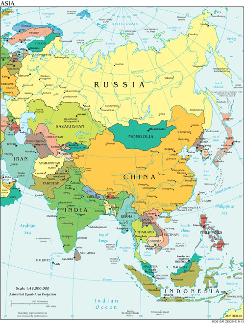
Start with the Arctic Ocean at the top, the Pacific on the right and the Indian Ocean toward the bottom. Find the Indian peninsula, the mainland of China, Japan's island chain and the Indonesian islands before following smaller country borders. These large features make orientation easier than starting with the dense labels around a disputed frontier.
How Big Is Asia on This Map?
The printed scale is 1:48,000,000. At the map's intended printed size, one centimeter represents 480 kilometers. On a website, browser zoom and screen size change the displayed centimeters, so use the map's distance bar rather than measuring the screen with a ruler. The bar is labeled in kilometers and miles.
The map identifies its projection as azimuthal equal-area. Equal-area maps preserve relative area, while shapes and other properties can change across the sheet. A long route should therefore be checked with appropriate distance tools rather than estimated from a straight line drawn on this small reference image.
National Geographic describes Asia as the eastern part of the Eurasian landmass, bounded by the Arctic, Pacific and Indian oceans. The division from Europe is a geographical convention with differing treatments around the Urals, Caucasus, Caspian and Black Sea. An exact continent total depends on the stated boundary convention. Adding the full national areas of Russia or other transcontinental countries is a different calculation from measuring the Asian portion.
Which Countries and Areas Does Asia Include?
The UN Statistics Division's M49 classification uses five Asian subregions. The table follows its country-or-area entries, checked November 10, 2026; familiar short names appear where helpful. M49 assigns whole countries or areas to statistical groups. It does not draw a physical continental boundary or decide political affiliation.
| Subregion | Countries or areas in the source | Map-reading distinction |
|---|---|---|
| Central Asia | Kazakhstan, Kyrgyzstan, Tajikistan, Turkmenistan, Uzbekistan. | A shared statistical group does not make the five countries one ancient kingdom. |
| Eastern Asia | China; China, Hong Kong SAR; China, Macao SAR; Democratic People's Republic of Korea; Japan; Mongolia; Republic of Korea. | The source category is “countries or areas,” so its entries are not a count of sovereign states. |
| South-eastern Asia | Brunei Darussalam, Cambodia, Indonesia, Lao People's Democratic Republic, Malaysia, Myanmar, Philippines, Singapore, Thailand, Timor-Leste, Viet Nam. | Mainland and island locations belong to the same statistical subregion. |
| Southern Asia | Afghanistan, Bangladesh, Bhutan, India, Iran, Maldives, Nepal, Pakistan, Sri Lanka. | M49 places Iran here, although a Middle East reference map also includes it. |
| Western Asia | Armenia, Azerbaijan, Bahrain, Cyprus, Georgia, Iraq, Israel, Jordan, Kuwait, Lebanon, Oman, Qatar, Saudi Arabia, State of Palestine, Syrian Arab Republic, Türkiye, United Arab Emirates, Yemen. | Much of this group lies beyond the western edge of the displayed Asia sheet. |
Russia is prominent in the map, but M49 assigns the Russian Federation to Eastern Europe. The chart and the classification answer different questions: one displays geographical coverage, while the other groups data. Similarly, Taiwan is labeled on the 2013 map but is not a separate entry in the M49 regional table reproduced here. Neither the image nor this table should be treated as the site's ruling on sovereignty or recognition.
Read Older Labels and Regional Limits
The map's “Burma” corresponds to Myanmar in the M49 list. Older geographical sheets also retain spellings and administrative labels from their publication period. A label is evidence of what that edition printed, rather than proof that it is the preferred present-day name.
Do not confuse a map's rectangular frame with the boundary of a region. Some European and African places appear at its left edge, while parts of Western Asia are omitted. The Middle East map-reading guide provides a complementary view and explains why its frame also contains neighboring countries.
The source warns that boundary representation is not necessarily authoritative. Country colors distinguish mapped units; they do not resolve contested borders, diplomatic recognition or control on the ground. For a present-day administrative question, use a dated source specifically addressing that question rather than this 2013 overview.
Modern Asia and the Asia of the New Testament
A modern continent map is the wrong scale for interpreting every biblical use of “Asia.” The Asia in the New Testament guide examines the western Asia Minor setting and the passages themselves. Do not extend a regional ancient name across the whole continent simply because the English word is the same.
Modern borders also cannot establish a country's descent from a person in Genesis or its identity in a prophecy. Those claims require separate textual and historical evidence. For ancient names and their limits, compare the Genesis 10 geography guide. Use the present page to orient modern places, then switch to a map appropriate to the period being studied.
Sources and Map Credit
- National Geographic Education, Asia: Physical Geography, opening geographical overview; used for continent scale, surrounding oceans and the Europe–Asia convention.
- UN Statistics Division, M49 country-or-area and geographical region tables, including its statistical-purpose and boundary disclaimers.
- CIA, Asia, August 2013. Pinned Commons source description and public-domain record; CIA source and copyright policies. This is an attributed third-party government map, not an original map created by LetsLearnTheBible.com; no agency endorsement is implied.
