Byzantine Empire Map in 1025 A.D.
Reader's question: View a Byzantine Empire map for 1025 A.D. and learn how Constantinople became the capital of the Eastern Roman Empire.
The map below is a snapshot near the end of Basil II's reign, which ended in 1025. Its purple area connects the Balkans, the Aegean and much of Anatolia around Constantinople. It does not show every territory the empire ever held. Comparing this date with Justinian's sixth-century reconquests or the much smaller state of the fifteenth century requires different maps.
Byzantine Empire map: 1025 A.D.
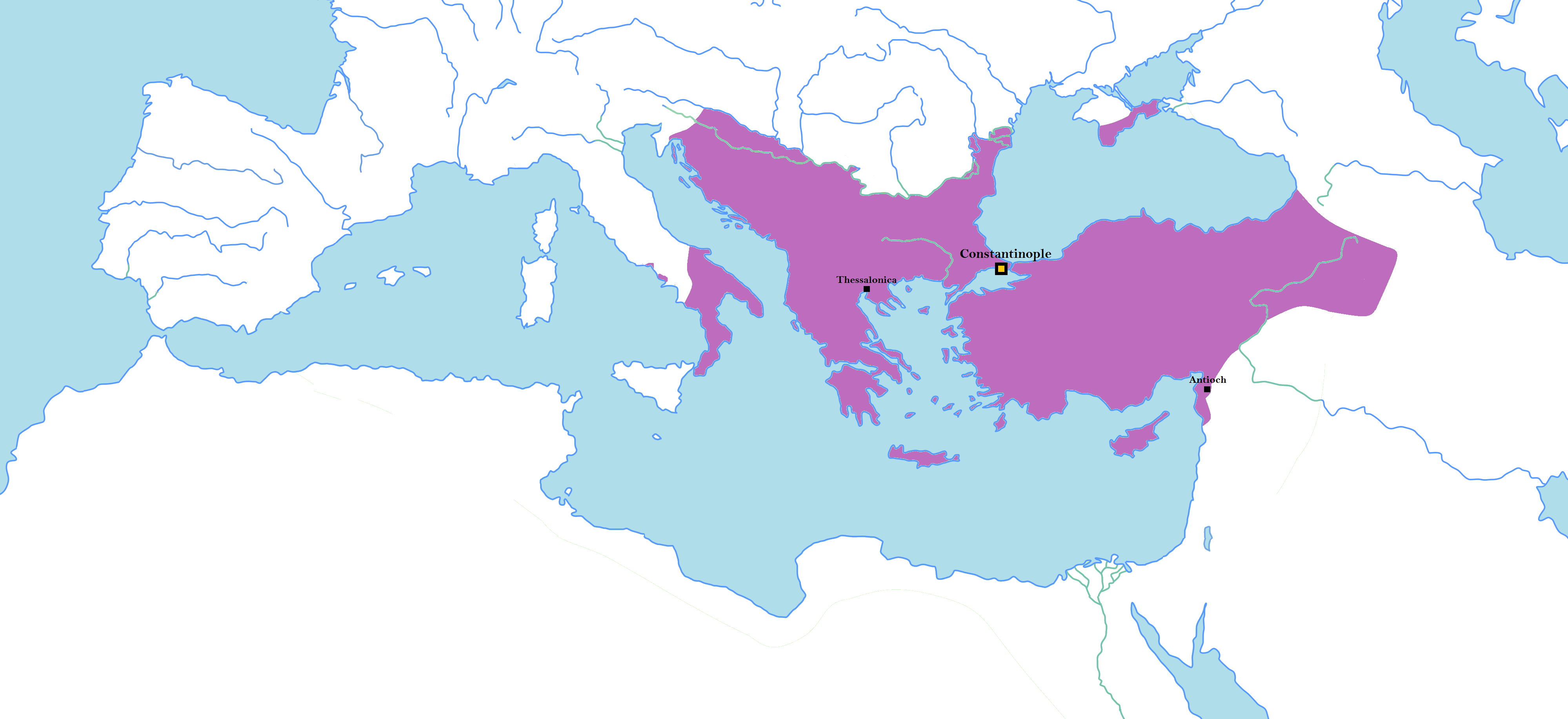

Start at Constantinople, where the Bosphorus separates southeastern Europe from northwestern Anatolia. Then follow the purple land west into the Balkans and east across Anatolia. The sea between these regions is a connection within the empire as well as a space between its provinces. Southern Italy appears across the water; the map does not make the entire Italian peninsula Byzantine.
| Area | Reading the geography | Limit of the picture |
|---|---|---|
| Constantinople | The capital links the European and Asian sides of the empire through the Bosphorus. | A capital marker does not mean every ruler exercised identical control over all purple land. |
| Balkans and Thessalonica | The western portion helps explain the importance of Basil II's Balkan campaigns. | This is the result depicted for 1025, not a map of every stage of those campaigns. |
| Anatolia and Antioch | These show the empire's substantial Asian territory and its southeastern reach. | Border lines are a modern reconstruction, not a surviving imperial boundary survey. |
| Southern Italy and surrounding seas | The western holdings make sense within a Mediterranean network. | The map omits shipping routes, provincial administration and modern national borders. |
Read a colored area as a historical model at the stated date. Local arrangements, disputed frontiers and degrees of authority cannot all be represented by one color. The map's reuse license establishes permission to display this particular image; it does not independently establish the accuracy of each border.
Was Byzantium a new empire?
“Byzantine Empire” is a later historical name for the medieval eastern Roman state. Its people identified with the Roman imperial tradition; they did not announce the foundation of a country named the Byzantine Empire in 395. The name is useful for distinguishing this long period from ancient Rome, but it can hide continuity in government, law and imperial identity.
Different starting points answer different questions. Constantine's development of Constantinople in the fourth century explains the capital. The division of imperial responsibilities after Theodosius I explains separate eastern and western courts. The disappearance of the western imperial office in the fifth century explains why the eastern emperor's position became distinctive. None of those dates alone describes the formation of every feature of medieval Byzantium.
By 1025 the empire had experienced centuries of political, linguistic, territorial and religious change. Calling Basil II a Roman emperor and using the modern label Byzantine are therefore compatible. Neither label makes the map a picture of the empire during Paul's travels: those journeys belong to a much earlier Roman setting.
How Constantinople became the capital
Constantine developed the existing city of Byzantium as an imperial capital and dedicated it in 330. Constantinople bore his name during his lifetime, not only after his death. Its position gave access between the Black Sea and the Aegean through the Bosphorus, while its harbor and nearby land routes supported trade, administration and military movement.
That geography helps explain the city's continuing importance, but location alone did not build or sustain the empire. Courts, taxation, armies, churches and investment in the city made it an administrative and religious center. Christopher Brooks's history of Byzantium is especially useful for connecting the capital's economic role with those institutions rather than reducing its prosperity to a single trade route.
Constantine's religious policies also belong to the background. The toleration measures of 311 and the agreement of Constantine and Licinius in 313 were separate steps. The 313 settlement protected religious practice and restored Christian property; it did not instantly turn every subject into a Christian. For the policy and its sources, see the Constantine map study.
Why 1025 must be compared with other dates
| Period | Historical change | How to compare with this map |
|---|---|---|
| Justinian, 527–565 | Imperial armies recovered North African and Italian territory from western successor kingdoms. | Do not transfer Justinian's reconquests onto a map labeled 1025. |
| Seventh century | War with Persia and subsequent Arab conquests transformed the eastern Mediterranean; Syria, Palestine and Egypt were lost. | Earlier eastern Roman provinces need not appear purple here. |
| Basil II, ending in 1025 | His campaigns strengthened imperial power, especially in the Balkans. | This is the period the displayed reconstruction represents. |
| 1071 and its aftermath | The defeat at Manzikert preceded major changes in Anatolia amid continuing struggles. | The defeat did not erase all Byzantine Anatolia on a single day. |
| 1204 and 1261 | Crusaders took Constantinople in 1204; Byzantine successor states continued. Constantinople was recovered in 1261. | Occupation of the capital and survival of successor states must both be considered. |
| 1453 | The Ottoman capture of Constantinople ended the empire centered there. | The territory immediately before the capture was far smaller than the purple area shown for 1025. |
The comparison also prevents a misleading story of uninterrupted decline after Basil II. Later rulers faced losses, recoveries, rival powers and internal conflicts. A map selected from one strong period cannot establish that later developments were inevitable. Michael Psellus's account of Basil II supplies a near-contemporary portrait of his government and campaigning, but its praise, criticism and personal judgments are not a geographical inventory.
Does Daniel name Justinian's restoration?
An earlier version of this article identified Justinian's restoration of Roman power with a particular horn in a sequence of imperial revivals. That is an interpretive identification. It should be evaluated separately from the map's historical date and the wording of Daniel.
Daniel 2:31–45 describes the statue's successive materials and kingdoms; Daniel identifies Nebuchadnezzar with the head of gold. Daniel 7:1–8, 15–28 describes four beasts, the fourth kingdom, ten kings represented by horns, another horn, and God's judgment. Those passages do not name Justinian, give the year 527, or identify him as a fourth revival. A reading that connects them to later Roman or Byzantine rulers needs additional interpretive arguments; the image of territory in 1025 cannot supply them.
This distinction allows a reader to study prophetic interpretations without treating an interpretation as a caption supplied by Scripture. It also leaves the historical questions answerable on their own: who governed, where authority extended, and how this date compares with other periods.
Sources and further reading
- Christopher Brooks, Western Civilization: Byzantium, especially the sections on Justinian, territorial changes and the capital and its rulers. These offer institutional and geographical background; individual estimates and broad judgments require care.
- Michael Psellus, Chronographia, Basil II, especially paragraphs 22, 30, 32 and 37 with the editor's chronological note. A primary portrait with an author's viewpoint.
- Mark Cartwright, Byzantine Empire, for a modern chronological overview and explanation of the historical label.
- Daniel 2:31–45; 7:1–8, 15–28 (KJV), for checking what the prophetic passages actually state.