Where Was the Temple Located?
Jerusalem’s temple belonged to the elevated sacred precinct now called the Temple Mount, also known as al-Haram al-Sharif. The evidence examined below distinguishes the sanctuary building from the platform supporting its courts, and distinguishes that precinct from the neighboring Antonia fortress. Identifying the broad setting does not settle the exact footprint of every ancient room.
How can we reconcile the destruction of Jerusalem’s temple in 70 A.D., prophesied by Jesus, with the existence of the Western Wailing Wall? Was the edifice built by King Solomon, and rebuilt by Herod, located on what is today referred to as the temple mount? Could it have been located somewhere else? Answering these questions requires reading the Gospel passages alongside the actual wording of Josephus and evidence from excavations, rather than making a surviving wall decide the geography by itself.
Locate the precinct and Wilson’s Arch
On the map, find the large outlined Temple Mount precinct east of the Western Wall Plaza. The black dot marks Wilson’s Arch on its western side; the yellow area is the plaza and the pink area marks the Western Wall Tunnels excavations. The north arrow and distance scale help separate a location from an impression based on a photograph. Mount Zion, near the lower left, is a label on this modern city map; it should not automatically be substituted for every biblical use of “Zion.”
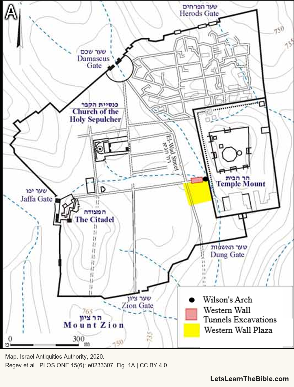
This is a locator map for an archaeological study, not a plan surveyed in Jesus’ lifetime. Its modern streets and religious buildings cannot be read as features all present in 70 A.D. It locates the excavation beside the precinct; it does not independently mark the Holy of Holies, the Gihon Spring or the complete outline of Antonia.
Which building or wall are we discussing?
| Structure | Evidence to read | What the distinction changes |
|---|---|---|
| The sanctuary and its associated temple buildings | Matthew 24:1–2 and Mark 13:1–2 begin with disciples pointing to buildings and their stones. Second Chronicles 3:1 places Solomon’s construction at Mount Moriah, at the prepared threshing floor of Ornan. | The sanctuary is not synonymous with every wall supporting or enclosing the wider hill. |
| The enlarged platform and surrounding courts | Josephus, Jewish War 5.5.1, describes enlargement through banks, supporting walls and colonnades. The Wilson’s Arch research examines access to the platform from its west. | The Western Wall belongs to the western retaining boundary of this larger precinct; calling it a surviving wall of the sanctuary confuses the scales of the structures. |
| Antonia fortress | Josephus, War 5.5.8, places it beside the junction of the northern and western temple colonnades and describes passages down to them. | A fortress adjoining and overlooking the temple is not thereby the whole temple platform. |
“Temple” can refer to the sacred building or, in a wider setting, its complex. An argument must therefore establish which structure a passage means before comparing it with a surviving archaeological feature. The distinction supports careful interpretation; it does not mean the wider city escaped the devastation of 70 A.D.
What did Jesus predict?
Matthew 24:1–3 describes Jesus leaving the temple, the disciples directing attention to its buildings, and his warning that their stones would be thrown down. Mark 13:1–4 likewise begins with a comment about the impressive stones and buildings. Luke 21:5–6 concerns the temple’s adornment and coming destruction. These immediate settings matter when identifying the objects of the warning.
Luke 19:41–44 is broader: Jesus weeps over Jerusalem and speaks of siege, its people and its leveling. It should not be silently reduced to the sanctuary alone. Equally, its language of comprehensive judgment is not an archaeological diagram specifying that every foundation course, retaining stone and later reused block must disappear. Readers may debate the force of that language and its prophetic scope; the location of an excavated structure must still be evaluated from evidence appropriate to that question.
The survival of part of the precinct’s retaining system does not demonstrate that the sanctuary survived, or require a second temple site near a spring. Destruction of a functioning sanctuary, devastation of a city and survival of some masonry are different historical claims. None should be settled by inserting a modern building identification into the Gospel text.
What did Josephus say survived?
In Jewish War 7.1.1, Josephus reports that Titus ordered the city and temple demolished while preserving three named towers—Phasael, Hippicus and Mariamne—and part of the city wall on the west. He explains the retained wall in relation to a garrison and the towers as witnesses to the city’s former strength. Section 7.1.2 then names the Tenth Legion and additional troops left behind.
This passage does not call the retained wall the four sides of Antonia, nor does it say the entire present platform survived intact as that fortress. The city’s west-side wall in this account must not simply be relabeled the modern Western Wall of the temple precinct: similar English names do not establish that they are the same structure.
A second passage, War 7.8.7, is part of a speech Josephus attributes to Eleazar at Masada. It evokes Jerusalem’s ruin and a Roman camp remaining amid it. The reference to a camp is not an explicit identification of Antonia. Nor should this rhetorically shaped speech be described as an independently transcribed eyewitness survey. Read its literary setting alongside the more detailed exceptions listed in 7.1.1.
Was the whole platform Fort Antonia?
Josephus’s description in War 5.5.8 provides a direct test. Antonia stands at the meeting of two temple colonnades, on the west and north. One of its towers is higher to permit a view over the temple, and passages allow guards to descend to the colonnades. His account distinguishes the fortress, the temple it overlooks and the routes between them.
Acts 21:30–40 supplies a separate narrative of soldiers coming down to rescue Paul from the crowd and taking him to the barracks, with Paul later standing on the stairs. The passage does not name Antonia or provide its dimensions. It can illustrate movement between the temple setting and a military installation, but the detailed identification must be argued from other evidence.
These sources do not support replacing the whole Temple Mount label with “Fort Antonia” and moving the temple south as a necessary consequence. Uncertainty about parts of the fortress’s reconstruction is a reason to qualify a plan, rather than to erase the structural distinctions the ancient description actually makes.
Does the Gihon argument establish another temple site?
First Kings 1:32–40 describes Solomon being taken to Gihon, anointed there and then brought up amid public celebration. It identifies a coronation scene. It does not say that Solomon later built the temple at that place. Second Chronicles 3:1 instead supplies its own construction setting: Mount Moriah and Ornan’s threshing floor. Linking two events involving Solomon is not sufficient to make their locations identical.
The water passages also need their contexts. Ezekiel 47:1–12 portrays water emerging from the sanctuary, deepening into a river and bringing life; Zechariah 14:8–9 describes waters flowing from Jerusalem in connection with the Lord’s kingship; Joel 3:16–18 includes a fountain from the Lord’s house. These visions should not be treated as records of an excavated Herodian plumbing system or measurements fixing a building beside Gihon.
A proposed southern location therefore needs positive geographical and archaeological evidence for the sanctuary itself. A coronation at a spring, imagery of life-giving water and a broad statement about destruction do not, together, establish that site. This guide does not treat the former article’s southern reconstruction as a demonstrated alternative.
Archaeology, dates and remaining limits
Regev and colleagues’ 2020 excavation study combined stratigraphy, microarchaeology and radiocarbon dating of short-lived organic material within construction mortars beneath Wilson’s Arch. They place the initial bridge construction within 20 B.C.–20 A.D. and its enlargement within 30–60 A.D. Those are modeled ranges for particular construction phases, not exact dates for every stone in the precinct.
The study matters because a bridge leading from the west to the Temple Mount was built and expanded before the revolt beginning in 66 A.D., and remains of that access system survived subsequent changes. Its investigators also distinguish later Roman, Byzantine and medieval features. A present archaeological scene can contain many periods; it cannot be assigned wholesale to a single rebuilding or destruction.
The excavated bridge is not the sanctuary floor. Its dating cannot by itself establish the Holy of Holies’ exact position, prove every detail of a reconstruction of Solomon’s building, or resolve theological readings of Jesus’ warnings. Taken with Josephus’s distinctions between temple, platform and fortress, however, it gives a firmer historical basis for this article’s broad location than the former argument that a surviving wall must be Antonia.
Sources and map credit
- 2 Chronicles 3:1–3 and 1 Kings 1:32–40: the temple construction setting and Solomon’s separate anointing at Gihon. Scripture references follow the King James Version.
- Matthew 24:1–3; Mark 13:1–4; Luke 19:41–44; 21:5–6: compare the immediate temple-building scenes with the warning concerning the city.
- Acts 21:30–40; Ezekiel 47:1–12; Zechariah 14:8–9; Joel 3:16–18: the stairs and military intervention, and the water passages in their own settings.
- Josephus, Jewish War 5.5.1 and 5.5.8: the platform’s enlargement and Antonia’s relation to the temple. 7.1.1–2 and 7.8.7: explicit surviving structures, the garrison and Eleazar’s speech. William Whiston’s translation, hosted by the University of Chicago; distinguish the ancient account from the host’s editorial notes.
- Regev, J., Uziel, J., Lieberman, T., and colleagues (2020), “Radiocarbon dating and microarchaeology untangle the history of Jerusalem’s Temple Mount: A view from Wilson’s Arch,” PLOS ONE 15(6): e0233307. See the introduction, Figure 1, construction-phase results and discussion. This is the excavation team’s report; the dates concern sampled contexts.
- Map: Figure 1A of that study, © Israel Antiquities Authority, 2020, under the article’s CC BY 4.0 terms. The publisher’s caption credits the separate artistic reconstruction in panel B to Ritmeyer Archaeological Design; that panel is not reproduced here. The crop and appended attribution are identified above.