The King's Highway was a road corridor east of the Jordan River and Dead Sea. Numbers names it when Israel asks to cross Edom and, later, the territory of Sihon king of the Amorites (Numbers 20:17; 21:22). These two requests locate the road in the Transjordan setting, but do not give a continuous surveyed itinerary from one distant terminus to another.
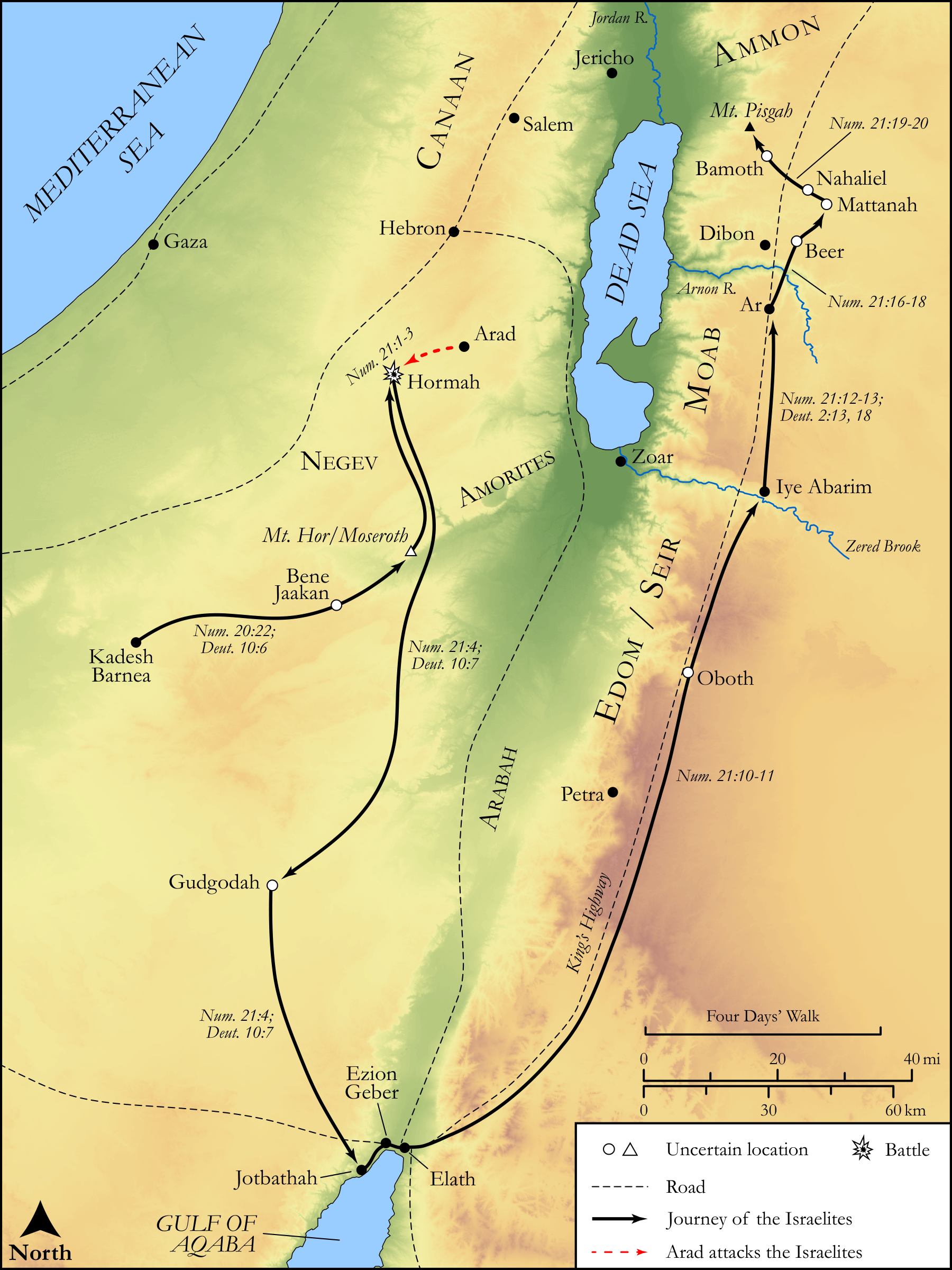
Where was the King's Highway located? Why was it important? What cities were on it, and who benefited from its existence? The two maps below show its southern and northern settings. Read the dashed road separately from the colored campaign arrows, then compare the place table with the actual passages. A route drawn by a modern cartographer is a geographical reconstruction, rather than a surviving map made by Moses.
Maps: follow the road, not every arrow
Begin with the Dead Sea and Gulf of Aqaba on the southern map. The dashed line labeled “King's Highway” runs through the highland corridor east of the Arabah and Dead Sea. The solid black arrows instead depict the mapmakers' reconstruction of Israel's journey around Edom and north toward Moab. The two lines sometimes approach each other; they do not mean that Edom granted the requested transit.

Continue on the northern map from Aroer and Dibon, near the Arnon, through the Heshbon district and north toward Bashan. Its dashed road again carries the King's Highway label. Black arrows show the Israelite campaigns; purple shows Sihon's movement and red shows Og's. The battle symbols mark Jahaz and Edrei. Those military movements are different information from the road itself.
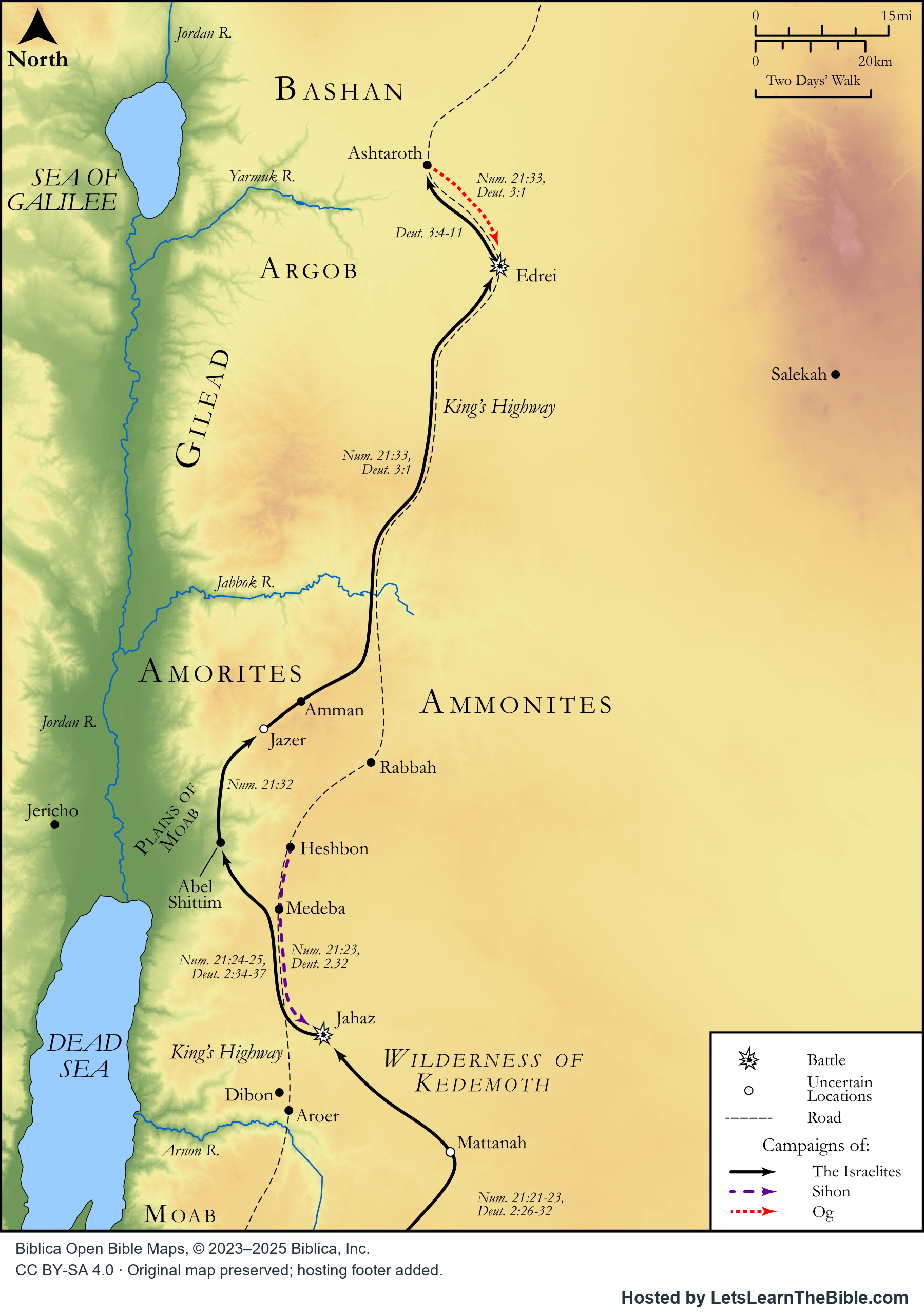

Both maps include north arrows, distance scales and a legend. Open circles or triangles identify locations the mapmakers regard as uncertain, including Oboth and Mount Hor on the southern map and Jazer and Mattanah on the northern map. Neither panel supplies a complete Damascus-to-Aqaba itinerary, a modern driving route, or exact boundaries for every period.
Places to find beside the corridor
| Place or district | Find it on the maps | What the text establishes |
|---|---|---|
| Edom / Seir | The southern highlands, east of the Arabah. | Moses seeks permission to use the king's highway through Edom; its king refuses (Numbers 20:14–21). Edom is a territory here, not a single roadside city. |
| Elath and Ezion-geber | At the northern end of the Gulf of Aqaba on the southern panel. | Deuteronomy 2:8 associates these names with the journey away from Esau's descendants. First Kings 9:26 locates Solomon's fleet beside Eloth in Edom; it does not name the road carrying its cargo. |
| Moab and the Arnon | East of the Dead Sea, with the Arnon running toward it. | Numbers 21:13 describes the Arnon as the border between Moab and the Amorites. This gives a narrative boundary for that episode, rather than a permanent border for every century. |
| Aroer, Dibon and Medeba | The northern panel places them near the dashed corridor north of the Arnon. | Deuteronomy 2:36 names Aroer in the conquest summary; Numbers 21:30 names Dibon and Medeba in the poem about the conflict. The passages do not say Israel stopped at each one in that order. |
| Heshbon and Jahaz | Heshbon lies by the dashed road; Jahaz is marked by a battle symbol farther south. | Heshbon is Sihon's royal city (Numbers 21:26). His army comes to Jahaz to fight Israel (21:23). A royal center and a battlefield serve different roles. |
| Rabbah, Gilead, Ashtaroth and Edrei | Use the northern panel for the wider region beyond Heshbon and the Jabbok. | Numbers 21:24 limits the conquest account toward Ammon, then 21:33–35 narrates the separate encounter with Og at Edrei. Seeing a city label near the road does not make it part of Sihon's kingdom or a stop in the same campaign. |
Why did access to the highway matter?
A through road lets travelers cross a territory without moving through cultivated fields. Moses' requests make that practical distinction explicit: Israel offers to stay on the road and avoid fields and vineyards (Numbers 20:17; 21:22). The renewed request to Edom also offers payment for water used by people or cattle (20:19). Access therefore involved supplies, local livelihoods and the authority of rulers as well as distance.
The wider geographical inference is that a north–south corridor could connect travelers and communities across the eastern highlands. Traders, residents and rulers controlling passage could benefit from such connections. The maps help explain that possibility; the two biblical requests concern a migrating people, rather than a surviving schedule of commercial traffic or toll receipts. They do not justify ranking this as the single most important road in every period.
Solomon's fleet provides evidence for maritime activity at Ezion-geber (1 Kings 9:26–28). It does not, by itself, prove that all the fleet's wealth traveled up this particular road. Likewise, a general biblical reference to a mineral, spice or trading people should not be used as evidence that a specific cargo followed the line drawn here.
Why did Edom refuse Israel passage?
Numbers 20:14–21 presents a request from Kadesh, an initial refusal, a further offer and a final armed response. Moses appeals to kinship and describes Israel's hardship. The king warns that passage will meet the sword. Israel then offers to pay for water and asks only to travel through, but Edom comes out with a substantial force and Israel turns away.
The text records Edom's decision without giving a detailed account of the king's private motives. Fear of a large migrating population or concern for resources may be plausible explanations, but they should remain interpretations. Numbers 21:4 subsequently describes a journey toward the Red Sea to go around Edom. On the southern map, follow the black journey arrows separately from the requested road.
What happened when Sihon refused?
In Numbers 21:21–26, Israel asks Sihon to let it use the king's highway without entering fields, vineyards or wells. Sihon refuses, gathers his people and attacks at Jahaz. Israel defeats him and occupies his territory from the Arnon to the Jabbok, with Ammon marking a further limit. The story identifies Heshbon as his city and explains that he had previously taken territory from Moab.
This outcome differs from the encounter with Edom: Israel turns away from Edom, but fights and takes Sihon's land. Deuteronomy 2:26–37 supplies a parallel account and explicitly describes the destruction of the captured towns' men, women and children. That violence belongs to the account and should not be reduced to a change of road access. The following battle with Og in Bashan is another episode, shown with its own red movement arrow on the northern map (Numbers 21:33–35).
Ancient route, modern road and uncertain sites
The Jordan Tourism Board's Biblical Jordan brochure describes a modern paved scenic road through the Jordanian highlands under the name King's Highway (printed page 22). A present road and the ancient corridor share a geographical setting and a traditional name; that does not establish that every bend of the modern pavement reproduces the road in Numbers. These two biblical maps should be used for historical reading, rather than navigation.
Ancient place identification also needs qualification. The same brochure notes that modern Hisban is commonly identified with Heshbon, while some scholars favor nearby Tell Jalul (printed page 17). Here, the map's Heshbon label locates the biblical setting as reconstructed by its cartographers; it is not a claim that an archaeological identification has been settled.
Genesis 14:5–7 names a campaign through several eastern places, but does not call its path the King's Highway. Similar geography cannot establish a continuous road used unchanged from Abraham to Moses and Solomon. Second Kings 14:7 names Selah in an Edomite campaign; the verse alone does not establish that Selah is Petra. Petra's appearance on the southern map is a regional landmark, rather than proof of that equation.
Sources and map credits
- Numbers 20:14–21 and 21:21–35: the two road requests, refusals, Heshbon and the battles.
- Deuteronomy 2:1–8, 26–37 and Numbers 21:4, 10–20: travel around Edom, the Arnon setting and Sihon's defeat. Scripture references follow the King James Version.
- Genesis 14:1–7; 1 Kings 9:26–28; 2 Kings 14:7: earlier warfare, Solomon's fleet and Selah, read without adding an explicit highway identification.
- Jordan Tourism Board, Biblical Jordan, printed pages 17 and 22 (PDF pages 19 and 24): modern Hisban candidates and the present scenic road. The brochure's stronger claims about Abraham's route and continuous use are not treated here as established by Genesis.
- Biblica OT036 metadata and OT037 metadata; publisher's license notice. The captions identify each map and any hosting adaptation. These licensed maps remain available under CC BY-SA 4.0.