Paul's Second Missionary Journey Map
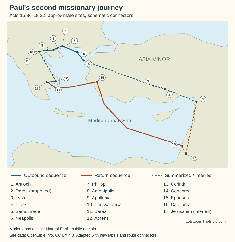
This large-view map follows the route narrated in Acts 15:36–18:22. It is designed to make the sequence and broad geography easier to inspect; the companion route guide explains the stops and cites the passage for each.
Route at a Glance
| Sequence | Place or region | Passage | Map note |
|---|---|---|---|
| Departure | Antioch in Syria; Syria and Cilicia | Acts 15:36–41 | Paul travels with Silas after separating from Barnabas, who sails to Cyprus with Mark. |
| Across Asia Minor | Derbe, Lystra, Phrygia, Galatia, Mysia, Troas | Acts 16:1–10 | Timothy joins the group at Lystra; the narrative describes changes in direction before the vision at Troas. |
| Macedonia | Neapolis, Philippi, Amphipolis, Apollonia, Thessalonica, Berea | Acts 16:11–17:15 | Acts names the travel sequence and describes teaching, opposition, and the new communities. |
| Achaia | Athens and Corinth | Acts 17:16–18:17 | Paul speaks in Athens and stays in Corinth, where Acts gives an eighteen-month period of teaching. |
| Return | Cenchrea, Ephesus, Caesarea, Antioch | Acts 18:18–22 | Acts names these stops. Jerusalem is often inferred from the unnamed church Paul greets at 18:22 and is marked as inferred on the map. |
What the Map Does Not Claim
Acts gives a sequence of places, not a complete travel diary. It does not provide a modern year range, state that the whole journey lasted forty months, or identify every road, harbor, and day of travel. The route lines therefore illustrate order and approximate direction, rather than surveyed ancient roads.
Place coordinates also involve uncertainty. Several proposed locations exist for some ancient sites; the map uses one approximate point for each label so that the route can be read at a glance. The Jerusalem stop is not explicitly named in Acts 18:22 and is shown as an inference, not a directly stated stop.
Map Sources
The route order was checked against Acts 15:36–18:22 in the KJV. Approximate site coordinates were adapted from OpenBible.info’s Bible geocoding dataset; the simplified coastline derives from Natural Earth. The route line, labels, uncertainty notes, and map layout are original artwork for this guide.
- Bible Gateway: Acts 15:36–18:22, KJV — route sequence and events.
- OpenBible.info Bible Geocoding and Acts KML dataset — approximate place coordinates, adapted under CC BY 4.0.
- Natural Earth — generalized coastline data, distributed under public-domain terms.
Content revised October 29, 2026. Send factual corrections or source questions through our contact page.