Paul's 'Fifth Journey': Map of Places and Evidence
A map of Paul’s proposed “fifth journey” brings together places mentioned in the letters and later accounts of his ministry. Those sources contain plans, remembered movements and historical traditions, but no single continuous itinerary. This map locates the references while keeping those differences visible.
“Fifth journey” is an editorial label for a reconstruction beyond the ending of Acts. It is not a numbered journey given in the biblical text. The purpose here is to help you find the places and evaluate what each reference contributes before deciding whether a particular route is justified.
Map: Reference Geography without a Continuous Itinerary
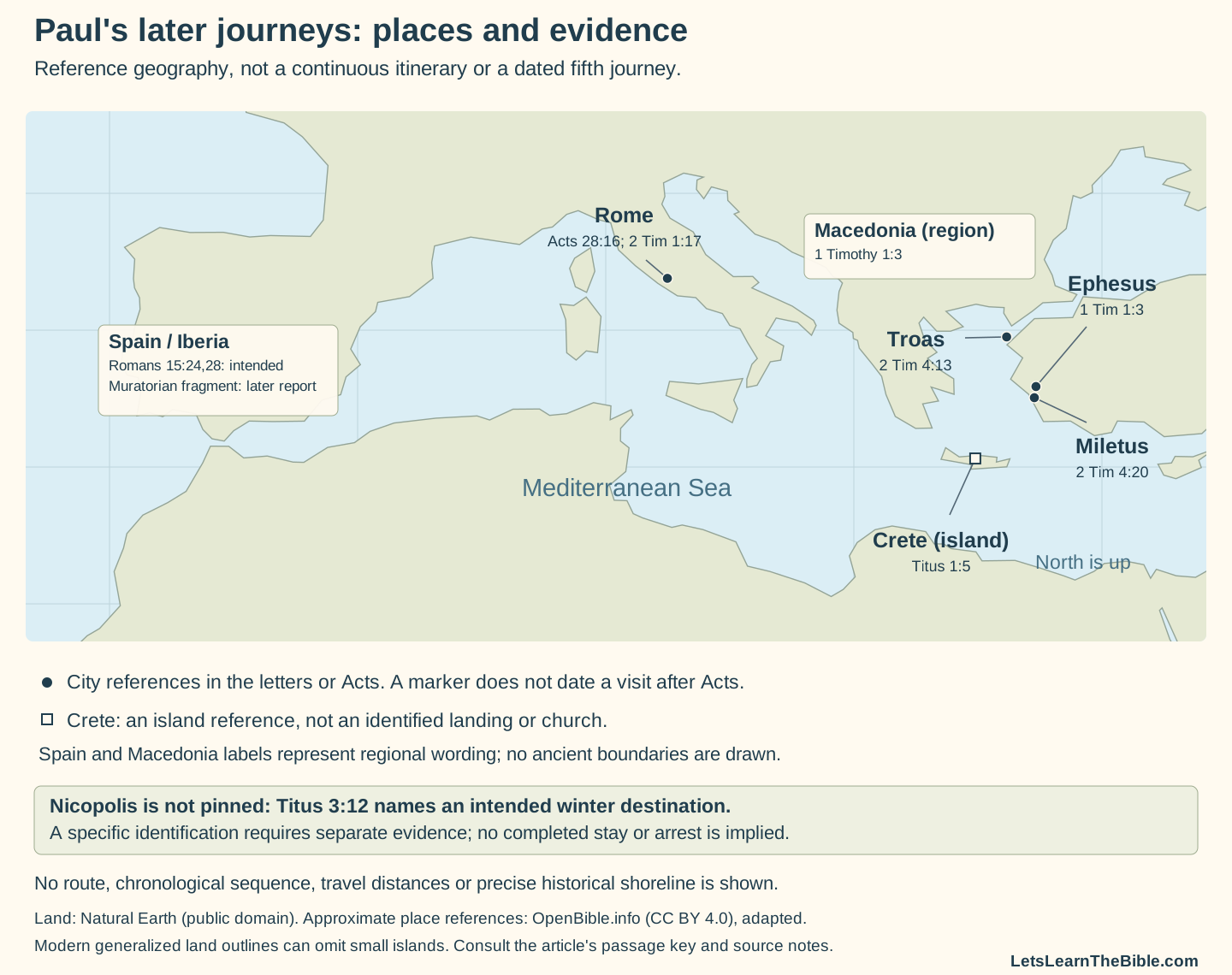
The map spans the Mediterranean from Iberia to western Asia Minor. It uses modern generalized land outlines to orient the reader, not to reconstruct ancient shores. The shapes and distances on the page should not be used to calculate Paul’s sailing time, exact walking route or the order of events.
Geographical identification and historical chronology are separate questions. A city can be located approximately even when the date of the movement mentioned in a letter is uncertain. Conversely, a place name may be clear in the text while its precise geographical identification requires further evidence. The unplotted Nicopolis illustrates that second problem.
What Does Each Place Reference Actually Say?
| Place and map treatment | Passage | Evidence and limit |
|---|---|---|
| Rome — city reference | Acts 28:16, 30–31; 2 Timothy 1:16–17 | Acts ends with a guarded residence and teaching. The letter remembers Onesiphorus seeking and finding Paul in Rome. A shared location does not, by itself, date all the notices to one imprisonment. |
| Troas — city reference | 2 Timothy 4:13 | Paul requests a cloak left with Carpus, along with books and parchments. The recollection does not give a calendar date or the next travel leg. |
| Ephesus — city reference | 1 Timothy 1:3; 2 Timothy 4:12 | Timothy is urged to remain at Ephesus when Paul goes into Macedonia; Tychicus is elsewhere said to have been sent to Ephesus. A companion's assignment is not automatically another visit by Paul. |
| Miletus — city reference | 2 Timothy 4:20 | Paul says he left Trophimus sick at Miletum, the KJV form of the name. The statement does not connect every preceding and following stop. |
| Crete — island reference | Titus 1:5–9 | Paul says he left Titus in Crete to address unfinished matters and appoint elders. Neither a landing place nor a complete island circuit is specified. |
| Macedonia — regional label | 1 Timothy 1:3 | The text names a region in a remembered movement. It does not name the port or the city at which Paul arrived, or date this notice against the end of Acts. |
| Spain — regional destination label | Romans 15:24, 28; Muratorian fragment's discussion of Acts | Romans states the intention; the later fragment explicitly refers to a Rome-to-Spain journey. Neither provides the Spanish landing place or a complete route through the peninsula. |
| Nicopolis — named but not pinned | Titus 3:12 | Paul asks Titus to join him where he has decided to winter. That does not report a completed winter stay, an arrest or a precise location established by this verse alone. |
This key is an evidence index, not a sequence. A proposed chronology must explain why a reference belongs after Acts and how it connects with the other references. Simply placing names on the same map does not supply that explanation.
Crete: An Assignment, Not a Mapped Church Circuit
Titus 1:5 gives the purpose of leaving Titus in Crete: matters remain to be set in order and elders are to be appointed in every city. The following verses discuss qualifications. Those instructions explain Titus’s task; they do not describe a completed tour by Paul and Titus or say that every appointment had already been carried out.
The map therefore marks the island as a reference area. Its square is not a proposed landing, a church address or a point from which arrows radiate to every town. Paul’s earlier voyage in Acts 27 also involves Crete, but that voyage cannot by itself date the situation described in Titus. For the earlier account, see the journey-to-Rome place key.
Questions about how elders were selected require a separate examination of the relevant texts. Titus’s instructions should not be converted into a confident claim about Greek wording or a particular completed process merely to fill out the narrative beside a map.
Why Are Some Destinations Labels rather than Dots?
Spain in Romans 15 is a destination in a future plan, set after Paul’s proposed delivery of aid to Jerusalem and a visit to Rome. No particular Spanish city is named. A marker at a modern capital or a guessed harbor would imply a specificity the passage does not provide. The regional label avoids that extra claim.
Later testimony adds to the discussion. 1 Clement 5 speaks of Paul’s western preaching and a western limit without naming Spain. The Muratorian fragment, in discussing what Acts omits, explicitly mentions his journey from Rome to Spain. Those are different forms of testimony, and neither supplies every connecting leg. The related study of the western evidence compares them more fully.
Macedonia is likewise regional wording rather than a named city in 1 Timothy 1:3. The label does not outline the borders of an ancient province or identify a particular arrival port. Nicopolis is treated differently again: it remains in the key, but no point is chosen without a separate geographical argument. The planned winter should not become proof that Paul stayed there or was arrested there.
The sources used for this map do not identify a British destination. A general phrase about the west cannot, without further argument, establish a visit to Britain, so no British journey is added.
What Would Be Needed to Connect the Points?
| Question | What the map does | What needs a separate argument |
|---|---|---|
| When? | Connects each label to a passage or historical source. | The dates and relative order of movements, including why they are placed after Acts. |
| Who traveled? | Distinguishes Paul's movements from instructions to companions. | Whether a companion's destination also represents a visit by Paul. |
| Which route? | Shows approximate geographical relationships. | The ports, roads, sailing stages and intervening stops actually used. |
| Was a plan completed? | Keeps the wording of an intention or request visible. | Evidence of the arrival, winter stay or visit, rather than the intention alone. |
Eusebius, Church History 2.22, relates renewed preaching after a defense and a subsequent return to Rome. That later account is relevant to a release-and-return framework. It is not a dated log connecting every name in this key. The study of Paul and Nero explains the difference between his reported tradition and a preserved trial record.
Philippians 2:24 and Philemon 22 also express anticipated visits. They help readers understand Paul’s expectations, but they should not be used as if they were notices that the visits had already occurred. No precise release year, arrest month, execution date or total prison term is attached to this map. Those questions need evidence beyond a collection of geographical references.
For study, choose one label and identify the action in its source: remembering, leaving, sending, asking, intending or reporting. Then list what you would need to know before drawing an arrow to the next place. The exercise keeps the map useful while making the assumptions of any fuller reconstruction visible.
Sources and Map Credits
- Biblical passages: Acts 28:16–31; Romans 15:20–29; 1 Timothy 1:1–7; Titus 1:1–9; 3:12–15; 2 Timothy 1:8–18; 4:6–22; Philippians 2:19–24; Philemon 20–25. Wording is checked against the King James Version.
- Historical comparison: 1 Clement 5; Muratorian fragment, paragraph 2 discussing Acts; Eusebius, Church History 2.22. The map does not turn these reports into an exact travel schedule.
- Land outlines: Natural Earth, public-domain map data, generalized and clipped to this view. Modern land is an orientation aid, not a reconstruction of ancient shores.
- Approximate locations: adapted from OpenBible.info Bible Geocoding, CC BY 4.0. City and island references were projected and relabeled for this map; regional labels do not represent precise point locations or boundaries.
- Further reading: Paul’s death and the limits of the historical testimony.