Paul's Journey to Rome: Map, Places and Evidence
Paul travels toward Rome in custody after his appeal to Caesar. Acts 27–28 follows the voyage through Sidon, Myra, Crete and a shipwreck, then the stay on Malta and the approach through southern Italy to Rome. The map below locates the named places while the key explains what kind of evidence each name provides.
This trip is sometimes called Paul’s “fourth missionary journey.” That numbering is an editorial way of organizing his travels, not a heading or numbered itinerary in Acts. Unlike a preaching circuit Paul chooses to organize, this journey begins with prisoners being entrusted to Julius. Paul continues to bear witness, but the transport and custody remain essential to understanding the route.
Map: Places in Their Narrative Order
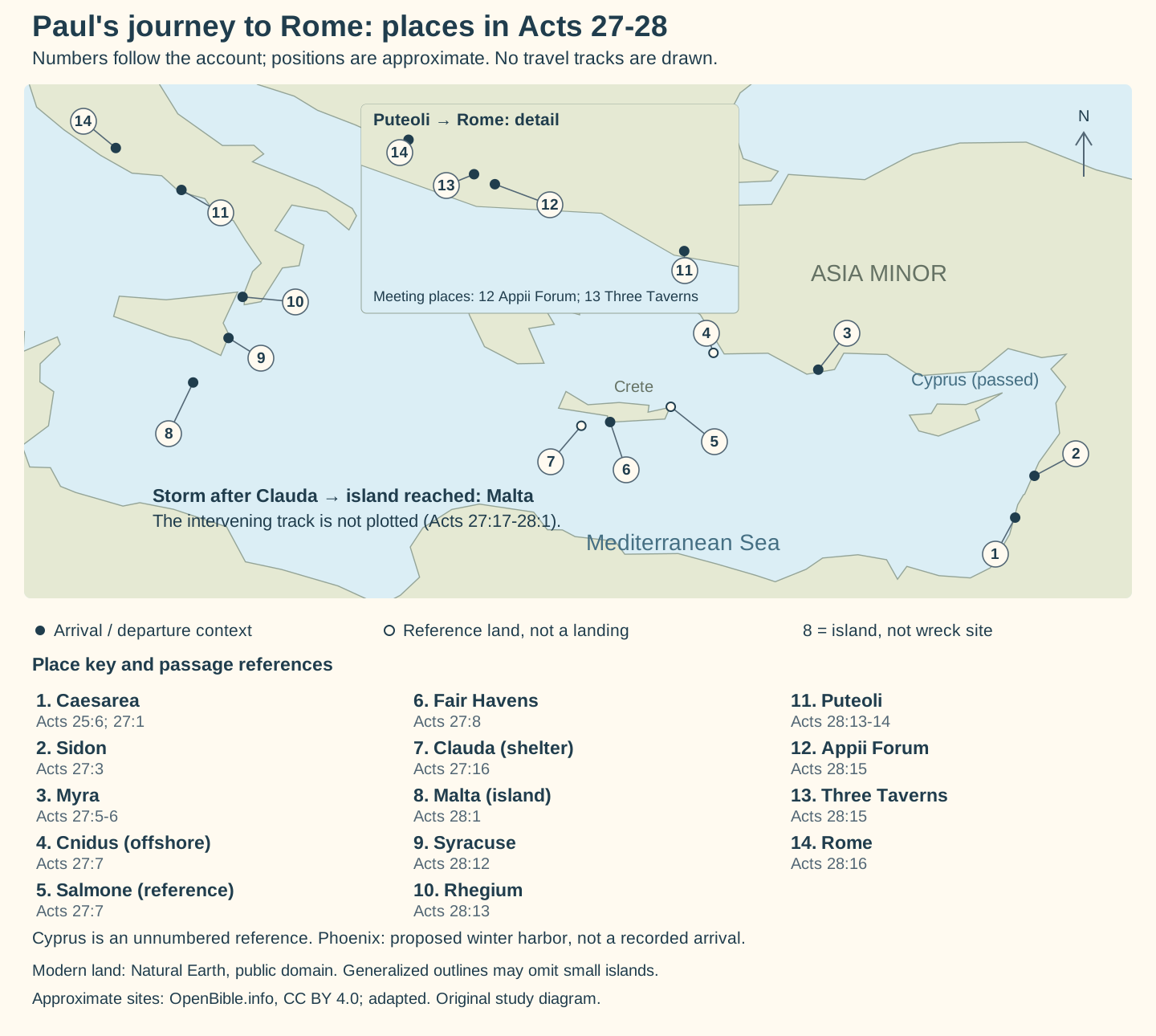
The numbers follow the order of the account, not distances or equal travel intervals. There are no road or sailing lines: a list of places can establish sequence without supplying a continuous track. Cyprus is named as a passed island, while Phoenix is an intended winter harbor; neither should become an extra arrival in the numbered list.
Which Names Establish an Arrival?
| Map number and place | Passage | What the account establishes |
|---|---|---|
| 1. Caesarea | 25:6–13; 27:1 | The setting of the accepted appeal and departure context. Acts 27:1 itself opens with the decision to sail to Italy rather than naming the embarkation port. |
| 2. Sidon | 27:3 | A stop the next day. Julius allows Paul to visit friends for care. |
| 3. Myra | 27:5–6 | An arrival in Lycia and a transfer to an Alexandrian ship sailing for Italy. |
| 4. Cnidus | 27:7 | An offshore reference during slow progress, not a narrated port call. |
| 5. Salmone | 27:7 | A reference near Crete as wind constrains the course; no landing is stated. |
| 6. Fair Havens | 27:8–12 | The anchorage reached with difficulty. Lasea is nearby; Phoenix is the later proposed winter destination. |
| 7. Clauda | 27:16–17 | Sheltering passage by the island, also known as Cauda/Gavdos. The marker locates reference land, not an exact boat position. |
| 8. Malta | 27:44–28:1 | The island named Melita in the KJV after everyone escapes. The island reference does not identify the precise wreck beach. |
| 9. Syracuse | 28:12 | A landing and three-day stay after departure from Malta. |
| 10. Rhegium | 28:13 | The next named arrival before a south wind helps the onward sailing. |
| 11. Puteoli | 28:13–14 | An Italian port where believers are found and a seven-day stay is requested. |
| 12. Appii Forum | 28:15 | One of the places as far as which believers from Rome come to meet the travelers. |
| 13. Three Taverns | 28:15 | The other named meeting place. The verse does not specify a separate overnight stay at each. |
| 14. Rome | 28:16 | The destination reached; Paul is allowed to dwell separately with a soldier guarding him. |
Adramyttium and Alexandria describe ships’ associations in this account. They are not additional visits Paul makes on the way to Rome. The map therefore does not turn the name of every ship’s home city into a numbered stop.
Why Three Ships Matter to the Map
The opening vessel is associated with Adramyttium and intended to sail along the coasts of Asia (27:2). At Myra Julius puts the travelers aboard an Alexandrian ship bound for Italy (27:6). That second vessel continues to Crete and is eventually wrecked.
After the island stay, the travelers leave in another Alexandrian ship that has wintered there (28:11). Its sign is Castor and Pollux. Treating all three vessels as one ship would obscure both the transfer at Myra and the fresh departure from Malta. For the opening people’s roles and route wording, see the first ships and stops.
Why Not Connect Clauda to Malta with a Precise Line?
Acts records adverse winds, the passage under Clauda, emergency measures, the fourteenth night in Adria and the eventual escape to an island (27:14–44). It does not supply a daily sequence of coordinates. A precise line would require a reconstruction of wind, speed, currents and the wreck location beyond what these verses directly provide.
The map therefore preserves the geographical endpoints without presenting an inferred drift as a measured track. This also avoids making Phoenix, which the travelers hope to reach, look like a successful stop. Read the storm and assurance guide for the decision sequence.
The ship carries 276 people in total, not 276 prisoners (27:37). The centurion prevents the soldiers’ plan to kill the prisoners; swimmers go first, and others use boards or wreckage (27:42–44). The map’s Malta marker cannot tell which method Paul personally uses. See the rescue sequence and the island stay for those distinct episodes.
From an Italian Port to the City of Rome
After Syracuse and Rhegium, the travelers reach Puteoli. The account then moves toward Rome, with believers coming out to Appii Forum and Three Taverns to meet them (28:12–16). Paul thanks God and takes courage on seeing them. The inset separates these closely spaced places so they are not lost behind a single Rome marker.
Acts 28:14–16 does not name the Appian Way or trace every road junction. Historical road evidence can help reconstruct the likely approach, but the passage’s named meeting places should be distinguished from an independently demonstrated road track. No road line is drawn here.
Relative Intervals Are Stronger Than Unexplained Calendar Dates
| Marker | Passage | How to use it |
|---|---|---|
| After two years, Festus succeeds Felix | 24:27 | Distinguish this Caesarea custody period from the later two years in Rome. |
| The fast is already past | 27:9 | A seasonal warning within the voyage; the verse supplies no modern year or September date. |
| The fourteenth night | 27:27 | A marker in the storm sequence, not the total duration from Caesarea to Rome. |
| Three months before leaving Malta | 28:11 | A different duration from Publius's three-day hospitality in 28:7. |
| Three days at Syracuse; seven days at Puteoli; two years in Rome | 28:12, 14, 30 | Keep each interval attached to its place rather than combining them into an unsupported exact arrival date. |
Chronologies may assign years by combining Acts with external historical evidence. This guide does not derive a precise departure, feast date or imperial-hearing date from verses that do not state one.
Arrival Is Not a Narrated Imperial Verdict
Rome is reached in Acts 28:16, but arrival does not end Paul’s custody. He later receives visitors and teaches, and the book closes with two whole years in his rented dwelling (28:17–31). It does not narrate a hearing before Nero, a final acquittal or Paul’s departure from Rome.
The appeal is explained separately in Festus’s hearing and Paul’s appeal to Caesar. Earlier Jerusalem events and the transfer to Caesarea precede this map’s scope; they should not be stretched into an extra sea voyage or used to turn every favorable comment into a formal release.
Sources and Map Credits
Primary passages: Acts 24:27; 25:6–13; 27–28. Short quotations use the King James Version. The map and tables independently organize the passage’s places, actions and intervals.
Land outlines use Natural Earth public-domain data. Approximate place coordinates are adapted from OpenBible.info geography data under CC BY 4.0. We selected and relabeled the points, added numbering, a separate Italy detail and the passage key. Modern generalized outlines may omit small islands and do not reconstruct ancient shorelines; ancient-site identifications and coordinates remain approximate.
The Malta point marks the island, not a wreck location. No maritime track is certified by this map. Send corrections through Contact; our editorial policy explains how uncertain identifications and reconstructions are handled.