Seven Churches of Revelation: Map and Place Guide
The seven churches named in Revelation 1:11 are Ephesus, Smyrna, Pergamos, Thyatira, Sardis, Philadelphia and Laodicea. Their cities lie in western Asia Minor, in what is now western Türkiye. Patmos is a separate island reference: John places himself there in 1:9, while the seven churches are the recipients to whom he is told to send what he sees.
Where Are the Seven Cities in Relation to Patmos?
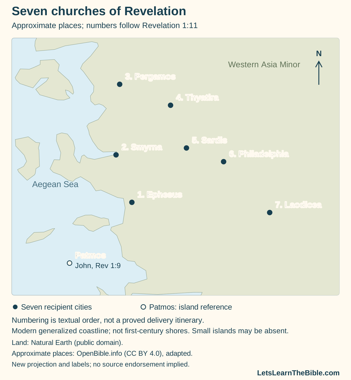
The pattern is easier to see when the names are plotted: the sequence goes from Ephesus north through Smyrna to Pergamos, then turns southeast through Thyatira, Sardis and Philadelphia toward Laodicea. This is a description of the plotted positions in the order of the text. It does not by itself establish how a messenger traveled between them.
The land layer shows generalized modern coastlines, not reconstructed first-century shores. Some small islands, including the outline of Patmos at this scale, are absent. Points locate approximate places; they do not identify the meeting building of each congregation. The map is for orientation rather than street navigation or measuring ancient travel distances.
Which Passage Corresponds to Each Map Number?
| Number and city | Relative position on this map | Message and study guide |
|---|---|---|
| 1. Ephesus | South of Smyrna; northeast of the Patmos reference. | Revelation 2:1–7 · Love, labor and the call to return |
| 2. Smyrna | North of Ephesus, near the western coast. | Revelation 2:8–11 · Suffering, poverty and faithfulness |
| 3. Pergamos | The northernmost of the seven plotted city references. Also called Pergamum or Pergamon. | Revelation 2:12–17 · Holding fast and confronting compromise |
| 4. Thyatira | Southeast of Pergamos and north of Sardis. | Revelation 2:18–29 · Love, service and tolerated teaching |
| 5. Sardis | South of Thyatira and east of Smyrna. | Revelation 3:1–6 · Reputation, watchfulness and the faithful few |
| 6. Philadelphia | Southeast of Sardis, before Laodicea in the textual sequence. | Revelation 3:7–13 · Little strength and an open door |
| 7. Laodicea | Southeast of Philadelphia; the easternmost of these seven plotted city references. The selected location is Laodicea on the Lycus. | Revelation 3:14–22 · Self-sufficiency, need and repentance |
“Pergamos” follows the KJV wording used in this guide. The coordinate source labels that location Pergamum/Pergamon; the spelling difference does not add an eighth church. Patmos likewise does not receive an extra number in the seven-city series.
What Does Revelation Say about John on Patmos?
In Revelation 1:9 John describes himself as the hearers’ brother and companion in tribulation, kingdom and endurance, and says he was on Patmos for the word of God and the testimony of Jesus Christ. Verses 10–11 then introduce the voice and the instruction to write and send the book. The island is the setting of this account, while the named cities identify its intended recipients.
The verse does not name the Roman emperor or supply a calendar year. A historical account of banishment under Domitian comes from evidence beyond that verse. Eusebius, Church History 3.18.1–3, reports John’s condemnation to Patmos and quotes Irenaeus’s statement linking the vision to the end of Domitian’s reign. In 3.20.10–11 Eusebius relates John’s return to Ephesus under Nerva and identifies it as an ancient Christian tradition.
Those passages help explain the traditional historical setting, but they are not extra sentences in Revelation 1:9. Distinguishing the two sources is more useful than assigning an unexplained “95 AD” label to the map or treating the map as proof of a precise date.
| Question | Source used here | What it establishes |
|---|---|---|
| Why does Patmos appear in the account? | Revelation 1:9–11. | John's stated location and testimony, followed by the instruction to send the book. |
| Where does the Domitian and Nerva account come from? | Eusebius, Church History 3.18.1–3; 3.20.10–11. | A later historical report, including cited earlier testimony and an expressly described tradition. |
| Where should the island be plotted? | The Patmos point in OpenBible.info's Revelation geographic data. | An approximate island reference, without identifying a cave or reconstructing the circumstances of writing. |
Does the Sequence Prove a Roman Postal Itinerary?
Revelation 1:11 supplies the order of the seven names, and chapters 2–3 follow it. A regional map makes that sequence geographically intelligible. Neither the list nor the messages, however, specifies the carrier, a road-by-road journey, travel times or a Roman postal-service arrangement.
A proposed delivery circuit needs separate historical and road evidence. This map therefore numbers the places without connecting them by roads or sailing tracks. Its northward and then southeastward pattern should not be mistaken for a surveyed itinerary, or for evidence that John personally visited every city on that journey.
Nor do the seven numbers mark seven dated eras of church history. Here their function is to help readers match a named recipient with a message. Any broader symbolic interpretation requires an argument from the text rather than a line or number added by a mapmaker.
How Can the Map Help without Replacing the Messages?
Use the place key to move between a city’s name and its passage, then read the address, evaluation, response and promise together. Geographic proximity does not make every congregation’s situation identical. Smyrna’s poverty and Laodicea’s confidence in riches, for example, receive different evaluations; locating them in one region does not erase that distinction.
For a comparison of all seven diagnoses and responses, use the seven-message reading guide. The individual studies linked in the table examine each paragraph. This page supplies their geographic orientation, not a replacement for those readings or a reconstruction of every city’s social history.
Sources and Map Credits
- Primary biblical text read in the KJV: Revelation 1–3, especially 1:4, 1:9–11 and the seven addresses in chapters 2–3. Read Revelation 1–3.
- Eusebius, Church History, Book 3, especially 3.18.1–3 and 3.20.10–11. Used for an attributed historical account, not copied as the article's narrative.
- Modern land: Natural Earth, 1:50 million land data, public domain. The map does not reproduce an ancient coastline.
- Approximate locations selected from OpenBible.info's Revelation KML; dataset explanation and attribution notice; CC BY 4.0. Changes: selection of eight point references, projection, numbering, labels and symbols. No photographs or regional boundary polygons are reused.
- The diagram's domain watermark identifies this site's presentation. The underlying geographic data retain their respective reuse terms; the sources do not endorse this page. Editorial policy.